Tourist City Planning Sand Table Model Making
Introduction
Tourist cities are different.
Hotels, beaches, airports, heritage sites, shopping districts.
Millions of visitors move through the same small area.
How do you plan for that?
Digital maps miss the human experience.
You need a physical model.
Specifically, a Tourist City Planning Sand Table Model.
This guide explains why tourism destinations need dedicated models.
What features matter.
And how to use them for better visitor experiences and economic growth.
Let us begin.
What Is a Tourist City Planning Sand Table Model?
It is a physical miniature of a tourism‑focused municipality.
Built on a sand‑textured base.
A Tourist City Planning Sand Table Model shows hotels, attractions, transportation hubs, pedestrian zones, and support services.
Unlike a general city model, this one emphasizes visitor flow.
Where do tourists arrive?
How do they move from the airport to the beach?
Where do they eat, shop, and sleep?
The model is used by tourism boards, resort developers, and municipal planning departments.
Why Tourist Cities Need a Dedicated Sand Table Model
Tourism planning is about experiences.
A visitor’s first impression, ease of navigation, and access to amenities determine success.
A Tourist City Planning Sand Table Model helps stakeholders see the visitor journey.
Hotel developers choose sites near attractions.
Transportation planners align shuttle routes.
Retail investors spot pedestrian bottlenecks.
Also, the model supports marketing.
A beautiful model sells the destination to investors and tour operators.
For public engagement, residents see how tourism growth affects their neighborhoods.
Key Features of a Tourist City Sand Table Model
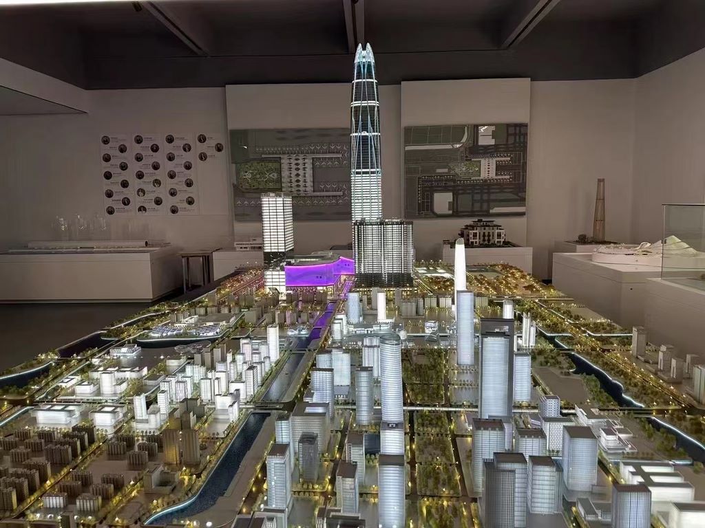
Let us break down what makes a model effective for tourism planning.
Visitor Arrival and Departure Nodes
Airport, cruise terminal, train station, bus depot.
Clearly marked with icons.
Accommodation Zones
Hotels, resorts, vacation rentals, hostels.
Different colors for luxury, mid‑range, and budget.
Attractions and Landmarks
Beaches, historic sites, museums, theme parks, viewpoints, marinas.
Distinct symbols or colors.
Pedestrian and Transit Circulation
Walkways, shuttle routes, tram lines, bike paths, ride‑share pickup zones.
Must be clearly distinguished from car traffic.
Support Infrastructure
Restaurants, shops, information kiosks, restrooms, medical facilities, parking garages.
Tourism Phasing
Phase 1, 2, 3 development zones.
Shows how the destination will grow over time.
Environmental and Cultural Buffers
Protected beaches, heritage zones, noise buffers around residential areas.
Critical for sustainable tourism.
Interactive Elements for Investor Presentations
Removable hotel blocks with LED indicators.
QR codes linking to investment prospectuses.
A well‑designed Tourist City Planning Sand Table Model answers the question: “Will visitors love this city?”
Materials for Tourist City Models
Tourist city models balance beauty and clarity.
Laser‑cut MDF or acrylic – For building massing blocks.
Colored acrylic sheets – For zoning (hotels, retail, attractions).
Blue epoxy resin – For pools, fountains, and coastal water.
Fine sand and textured paint – For beaches and plazas.
Flocking – For parks and green spaces (sparingly).
Printed vinyl – For attraction icons and labels.
LED strips – For highlighting transit routes and key landmarks.
Avoid clutter – the visitor experience should be instantly readable.
The Custom Production Process: Step by Step
How is a tourist city planning sand table model made?
Here is the typical workflow.
Step 1: Tourism Master Plan Review
You provide land use maps, transit studies, attraction locations, and phasing schedules.
The model maker identifies visitor flow corridors.
Step 2: Scale Selection
Common scales: 1:1,000 to 1:5,000.
1:1,000 for a detailed resort district.
1:2,500 for a whole tourist city.
Step 3: Base and Terrain
A reinforced MDF or aluminum base is cut.
Beaches, coastlines, and rivers sculpted or cast in resin.
Step 4: Arrival and Circulation Nodes
Airport, cruise port, and transit hubs marked.
Major pedestrian and shuttle routes painted.
Step 5: Zoning and Attractions
Hotel zones (gold), retail zones (orange), attractions (purple), open space (green).
Landmark buildings (e.g., casino, museum) shown in more detail.
Step 6: Support Infrastructure
Restaurants, restrooms, medical clinics, parking added as simple icons.
Step 7: Phasing and Growth Areas
Phase 1, 2, 3 distinguished by color intensity or patterns.
Future hotel sites shown in outline.
Step 8: Interactivity and Labels
Removable hotel blocks for investor roadshows.
LED transit routes.
Legend panel explains colors and symbols.
Step 9: Quality Control and Cover
The model is inspected for legibility from visitor perspective.
A clear acrylic cover or low railing is added.
A custom Tourist City Planning Sand Table Model typically takes 8 to 12 weeks.
Applications for Tourist City Models
Where are these models used?
Tourism Master Planning
Coordinate hotel, attraction, and infrastructure development.
Investment Promotion
Attract hotel chains, retail brands, and entertainment operators.
Public Engagement and Resident Workshops
Show how tourism benefits the local economy.
Address concerns about traffic and noise.
Destination Marketing
Use the model in trade show booths.
Sell tour operators on the visitor experience.
Disaster Preparedness for High‑Density Areas
Plan evacuation routes from crowded beaches and hotels.
Integration with Other Planning Models
An Industrial Park Urban Planning Scale Model might be needed for a nearby logistics zone supporting the tourist city – but the two models serve different purposes.
Case Study: Tourist City Model Drives $500M in Hotel Investment
A Caribbean island planned a new tourist district.
After two years of slow hotel development, they needed to attract major brands.
They commissioned a Tourist City Planning Sand Table Model at 1:1,500 scale, covering a 2.5m x 2m table.
The model showed the beach, a new marina, a convention center, and 40 hotel plots color‑coded by phase.
LEDs highlighted pedestrian shuttle routes.
Available plots had small green LEDs.
At a global tourism investment summit, the model was the centerpiece.
Three international hotel chains committed $500 million.
The model cost $32,000.
The return was over 15,000 times.
Cost Factors for Tourist City Models
Area covered – 20 sq km vs. 200 sq km.
Scale – 1:1,000 (more detail) costs more than 1:5,000.
Attraction and landmark detail – Basic blocks vs. custom 3D printed landmarks.
Pedestrian circulation detail – Simple roads vs. detailed walkways and transit routes.
Interactivity – Static vs. removable hotel blocks and LED transit lines.
Typical range: 70,000 for a large tourist city with detailed attractions and interactive investment features.
How to Choose a Model Maker for Tourist City Projects
Experience with tourism or hospitality models – Not just residential planning.
Understanding of visitor flow – Pedestrian and transit systems must be clear.
Ability to create attractive landmark models – Iconic buildings need more detail.
References from tourism boards or resort developers – Call two.
Ask for a sample of how they represent a cruise terminal and a beachfront hotel district.
Maintaining and Updating Your Tourist City Model
Tourist cities evolve as new hotels and attractions open.
Use magnetic hotel blocks – Switch “planned” to “open” colors.
Replaceable attraction icons – Update as new rides or museums open.
Annual review – Compare to current occupancy and visitor numbers.
Budget for updates – Every 2–3 years for major changes.
For cost‑effective updates, a City Planning Scale Model approach with modular components is ideal – request removable attraction and hotel blocks.
Display Tips for Maximum Impact
In a Tourism Investment Center
Low pedestal with dramatic spotlights.
Touch screen legend with parcel details and investment contacts.
At Travel and Trade Shows
Portable version on a wheeled cart.
Battery‑powered LEDs for shuttle routes.
For Public Engagement
Place the model in a community center.
Provide non‑laser pointers for residents to trace their concerns.
Common Mistakes to Avoid
Do not ignore pedestrian circulation.
Visitors walk – the model must show sidewalks and crossings.
Do not forget arrival nodes.
Airport and cruise port connections are critical for investor confidence.
Do not make all hotels look the same.
Distinguish luxury from budget zones with colors or textures.
Do not skip support facilities.
Restrooms and medical clinics matter for visitor satisfaction.
Do not omit a legend.
Without a legend, viewers cannot interpret the colors and symbols.
Integrating with Other Planning Model Types
A tourist city model often complements regional planning tools.
An Urban Construction Sand Table Model takes over during new hotel or attraction construction – showing phasing and temporary visitor impacts.
For economic context, a City Economic Zone Planning Scale Model might cover a free trade zone adjacent to the tourist district – your model focuses on the visitor experience.
For coastal tourist cities, a Coastal City Urban Planning Sand Table Model adds sea‑level rise and beach erosion context – critical for long‑term resilience.
Each type serves a different purpose. The tourist city model is the specialized tool for destination planning.
Future Trends in Tourist City Sand Table Models
Real‑time visitor data – LEDs show congestion levels on popular streets.
Augmented reality – Scan the model to see hotel room views or attraction wait times.
Seasonal overlays – Swap summer beach scene for winter festival layout.
Sustainability features – Show electric shuttle routes and green hotel certifications.
Yet the core remains.
Destination planners need to see the visitor journey.
A physical model does that best.
Conclusion
A Tourist City Planning Sand Table Model is an essential tool for designing world‑class destinations.
It attracts investment, coordinates development, and improves visitor experiences.
Focus on arrival nodes, pedestrian flow, and attraction visibility.
Add interactive features for investor roadshows.
Plan for updates as the city grows.
Whether you are a tourism board, resort developer, or municipal planner, invest in a custom model.
Your visitors will navigate easily.
Your economy will thrive.
And remember – whether you need an Industrial Park Urban Planning Scale Model for a logistics zone, a City Planning Scale Model for general land use, an Urban Construction Sand Table Modelfor project phasing, a City Economic Zone Planning Scale Model for adjacent free trade areas, or a Coastal City Urban Planning Sand Table Model for shoreline context, each has its role. But for pure destination planning, the tourist city planning sand table model is unmatched.
Model your paradise. Welcome the world.


